
The first time I stood on the Imi n’Ouaka Pass, looking south across the Jbel Saghro massif toward the palm groves of N’Kob, I understood why the Aït Atta chose this place to make their last stand against the French.
You can see everything from up here. The basalt pinnacles that look like the spires of a cathedral built by a god who forgot to add the walls. The dry riverbeds that turn into waterfalls for exactly three days each spring. The distant blue line of the High Atlas, a hundred kilometres north, holding snow while you stand in 20-degree heat. And no one else. Just you, the wind, and a silence so complete you can hear your own pulse.
If you have searched for Jbel Saghro trekking before, you already know the problem: there is almost nothing out there. Most trekking content about Morocco funnels you toward Toubkal, the M’Goun Massif, or the standard Marrakech-to-Merzouga circuit. Jbel Saghro — a 2,712-metre volcanic massif squatting between the High Atlas and the Sahara — remains invisible in the search results.
This guide changes that. It covers the Jbel Saghro trekking experience end to end: the stark lunar landscapes of the Anti-Atlas, the cultural depth of the Aït Atta nomads who call this mountain home, the hidden village of N’Kob with its 45 forgotten kasbahs where the trek ends, and the complete day-by-day breakdown of our real 6-day Jbel Saghro trekking adventure from Marrakech.
We are Morocco Desert Gateway, a licensed Moroccan travel agency based in Marrakech. Our guides were born in the shadow of these mountains, and we wrote this guide because the trail deserves a voice that matches its quality — not thin marketing copy, but the real thing.
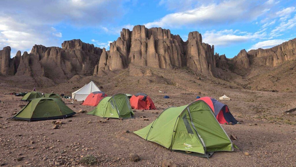
Table of Contents
- Jbel Saghro vs. Mount Toubkal: Why Saghro Wins
- What You Will See: Lunar Landscapes, Gorges, and the Aït Atta Way of Life
- N’Kob: The Hidden Village of 45 Forgotten Kasbahs
- The Real 6-Day Jbel Saghro Itinerary from Marrakech
- Best Seasons and Weather for Jbel Saghro Trekking
- Frequently Asked Questions
Jbel Saghro vs. Mount Toubkal: Why Saghro Wins {#saghro-vs-toubkal}
Let me settle this directly. If you are choosing between Toubkal (4,167 m) and Jbel Saghro (2,712 m) for a Moroccan trekking holiday, here is how they actually compare — not the marketing version, but the truth.
| Comparison | Toubkal (High Atlas) | Jbel Saghro (Anti-Atlas) |
|---|---|---|
| Max altitude | 4,167 m | 2,712 m (trek crosses Imi n’Ouaka Pass, approx. 2,500 m) |
| Crowds | 100+ summits per day in peak season | 0–10 trekkers per week |
| Terrain | Alpine — scree, snow, rocky ridges | Volcanic — basalt pinnacles, gorges, lunar plateaus |
| Green factor | Lush valleys, juniper forests | Stark desert-mountain — almost no vegetation |
| Cultural access | Limited — quick overnights in villages | Deep — guesthouses, bivouacs, nomad encounters |
| Winter trekking | Difficult — snow, technical gear needed | Excellent — mild days, clear skies, no snow |
| Best season | May–October | November–February (winter is prime time) |
| Photography | Classic alpine panoramas | Martian landscapes, surreal rock formations |
| Guides needed? | Yes, legally required above refuge | Yes, essential — trails are entirely unmarked |
Toubkal is a summit objective — a physical challenge with a fixed goal. You wake up at 5 AM, you climb, you take a photo, you descend. The view from the top is spectacular, but you share it with a hundred other people.
Jbel Saghro is a journey. You are not racing to a peak. You are moving through a landscape that changes every hour — from basalt pinnacles the size of apartment blocks to hidden palm groves where the only sound is water running through a stone channel. You camp in bivouacs pitched in places that do not appear on any map. You eat dinner cooked over a fire by a dedicated trek cook who learned the recipes from his mother.
Jbel Saghro trekking offers something Toubkal cannot: genuine solitude. In six days on the traverse, you might see three other people. The shepherds you meet do not work for tourism companies. They are Aït Atta families moving goats between seasonal pastures, just as their grandparents did, and their grandparents’ grandparents before that.
If alpine altitude is what you’re after instead, our 7-Day M’Goun Summit Trek from Marrakech is the High Atlas answer — but read on before you decide.
What You Will See: Lunar Landscapes, Gorges, and the Aït Atta Way of Life {#what-you-will-see}
The geology of another planet
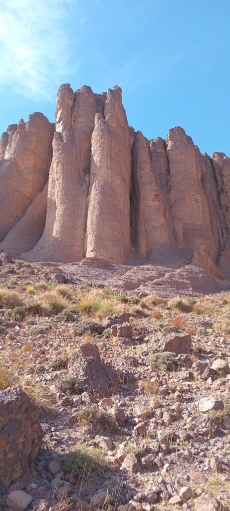
Jbel Saghro is a volcanic massif — the eroded skeleton of an ancient volcanic system. What you walk through today is what deep time left behind: basalt columns that rise from the ground like organ pipes, rhyolite domes that glow orange in the afternoon sun, and compressed volcanic ash that erodes into shapes that look deliberate: arches, needles, faces in profile.
The most famous formations in the massif are the Bab n’Ali Needles — pointed pinnacles of dark volcanic rock, some 40 metres tall, clustered together like a row of needles stuck into the earth. The name translates to “Ali’s Doorway.” When the wind blows through the gap, it makes a low hum that the Aït Atta say is Ali calling his camels. Our standard route crosses the heart of the massif via the Imi n’Afourar Gorge and the Imi n’Ouaka Pass; private departures can be routed via Bab n’Ali on request — contact us to customize.
Gorges and hidden valleys
The trail threads through the Imi n’Afourar Gorge, where vertical walls of dark volcanic rock funnel sunlight into a single shaft at midday. In spring, seasonal streams run clear over pebble beds. The ground underfoot is polished stone, worn smooth by flash floods that have run through here for millennia. Between the gorges, the route crosses rocky plateaus and traditional nomadic routes with panoramic views that stretch, on clear winter days, from the snows of the High Atlas to the haze of the Sahara.
Oases that appear from nowhere
After days of walking through volcanic scree — brown, grey, beige, nothing but stone and dust — you descend from the Imi n’Ouaka Pass and the world changes colour. The transition is abrupt: from monochrome to green. The palm groves of N’Kob spread below you, fed by water channels that have run for centuries. After days of dry, dusty walking, that first view of the oasis is not scenery. It is a sacrament.
The history written in stone
No guide to Jbel Saghro trekking is complete without the Battle of Bougafer (1933). Jbel Bougafer is a summit in the Saghro range where the Aït Atta mounted their final resistance against French colonial forces. For weeks, Aït Atta warriors led by Assou Oubasslam held off a vastly larger French force supported by military aircraft. They lost. But the battle is still taught in Berber families today as the moment the tribe proved what it was made of.
When you trek through Saghro with a local guide, you are walking through a landscape his ancestors defended. You find yourself looking at the ridges differently — not as scenery, but as defensive positions. The landscape itself becomes the story.
N’Kob: The Hidden Village of 45 Forgotten Kasbahs {#nkob}
Most travellers cross the Anti-Atlas without stopping. They drive the N9 and N12 between Ouarzazate and Zagora, ticking off Ait Ben Haddou and the Draa Valley, and miss an entire chapter of Moroccan history sitting quietly off the main road.
N’Kob is that chapter — and on our route, it is the reward waiting at the end of the trek.
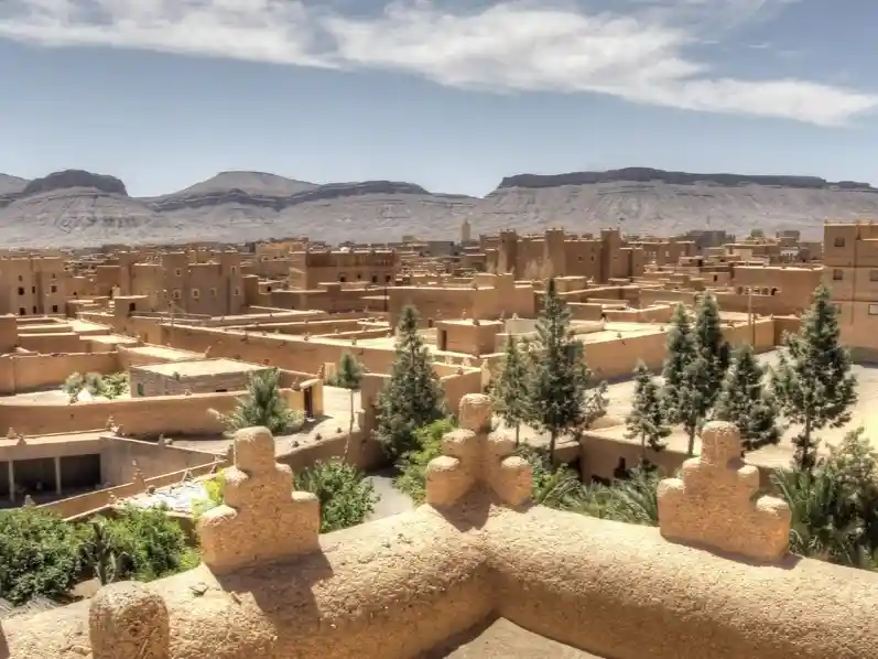
This Berber village of roughly 3,000 people sits at around 1,050 metres, wedged between palm oases at the southern foot of Jbel Saghro. Its most striking feature is immediately visible: kasbahs. Forty-five of them. Some restored, their tapered towers freshly plastered with the same mud-and-lime mix used for centuries. Others crumbling slowly back into the earth, their geometric patterns eroded by wind into ghost inscriptions.
They were not built for tourists. N’Kob sat at the crossroads of caravan routes connecting the Draa Valley and the Tafilalt with trans-Saharan trade. The kasbahs were built by wealthy merchant families and tribal leaders of the Aït Atta confederation — each one both a fortified home and a caravanserai.
Walking through the narrow alleys of N’Kob on the final evening of your trek, you pass children playing in doorways, women preparing bread in courtyard ovens, and the occasional goat wandering through a kasbah archway as if it owns the place. This is not a museum village staged for tourism. This is a living community that happens to live inside history. You sleep that night in a village guesthouse — thick mud walls that hold the day’s warmth, a courtyard where mint grows in terracotta pots, dinner cooked by the family.
The Real 6-Day Jbel Saghro Itinerary from Marrakech {#itinerary}
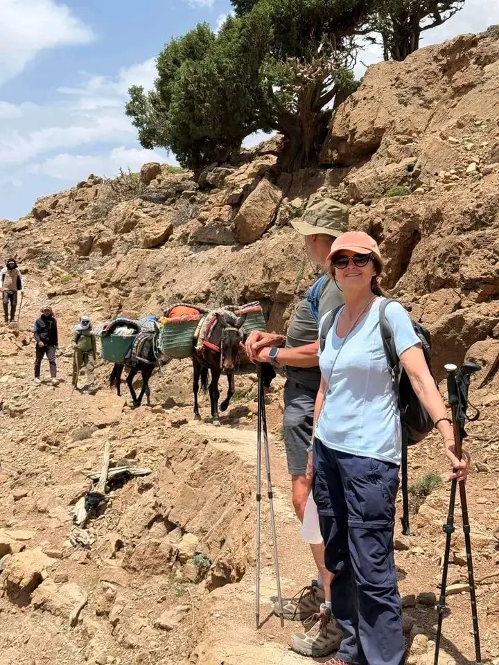
This is the exact route of our 6 Days Jbel Saghro Trekking Adventure from Marrakech — a fully supported traverse with a professional mountain guide, a dedicated trek cook, muleteers, camp assistants, and pack mules that know the trail better than Google Maps. You carry only a daypack.
Difficulty: Moderate. No technical climbing. Walking 4–5 hours per day. Maximum altitude is the Imi n’Ouaka Pass at approximately 2,500 m. The real challenge is the exposure — there is almost no shade on the Saghro trail.
Day 1 — Marrakech to Taoudilt (via Tizi n’Tichka, Ait Ben Haddou & Dades)
Pickup in Marrakech between 07:00 and 08:00 (Bab Doukkala is the main departure point). The road climbs through the High Atlas via the Tizi n’Tichka Pass (2,260 m), then stops at the UNESCO World Heritage Site of Ait Ben Haddou for a guided visit — included in the tour. You continue through Ouarzazate, the Skoura Oasis, and Boumalne Dades before reaching Taoudilt, the trailhead village on the northern edge of the massif.
Overnight: Guesthouse in Taoudilt.
Day 2 — Taoudilt to Imi n’Ouarg
The trekking begins. The trail crosses rocky plateaus, mountain passes, and traditional nomadic routes, with panoramic views opening over the volcanic wilderness ahead.
Walking: 4–5 hours · Overnight: Bivouac camp (guesthouse in bad weather).
Day 3 — Imi n’Ouarg to Imi n’Afourar Gorge
Deeper into the heart of Saghro. Impressive rock formations, hidden valleys, and the dramatic Imi n’Afourar Gorge — desert-mountain scenery found nowhere else in Morocco. Dinner by headlamp. The stars in Saghro are so bright you can read by them.
Walking: 4–5 hours · Overnight: Bivouac camp (guesthouse in bad weather).
Day 4 — Imi n’Afourar Gorge to Handour
A beautiful day through rocky desert, mountain ridges, volcanic formations, and remote nomadic territory. The vegetation thins to nothing; the ground underfoot is volcanic scree — loose, sharp, dark. You camp near Handour, surrounded by nothing but rock and sky.
Walking: 4–5 hours · Overnight: Bivouac camp (guesthouse in bad weather).
Day 5 — Handour to N’Kob via the Imi n’Ouaka Pass
The high point of the trek. You cross the Imi n’Ouaka Pass (approx. 2,500 m) — the massif laid out in layers of basalt, rhyolite, and dust behind you, the green line of the N’Kob palm groves appearing far below. The descent channels you out of the mountains and into the oasis. You arrive in N’Kob in the late afternoon with time to walk among the kasbahs before dinner.
Walking: 4–5 hours · Overnight: Guesthouse in N’Kob.
Day 6 — N’Kob to Marrakech
After breakfast, departure toward Marrakech via Ait Saouen, travelling through Southern Morocco’s landscapes one last time. Arrival in Marrakech in the evening — dust still in your boots, mint tea still on your tongue.
Optional extension: trekkers who want more can add a 2-day Sahara extension to Merzouga and the Erg Chebbi dunes — camel trekking, a night in a desert camp, sunrise over the Sahara. See our Sahara Desert Tours or ask when booking.
What’s included: private transport, professional mountain guide, guided Ait Ben Haddou visit, all accommodation, full bivouac equipment, mule team and handlers, trek cook, 5 breakfasts / 4 lunches / 5 dinners, mineral water on the trek, and all logistics. From €650 per person.
Best Seasons and Weather for Jbel Saghro Trekking {#seasons}
This is where Jbel Saghro outranks every other Moroccan trekking destination.
Winter (November–February) — the prime season
While the High Atlas is buried in snow and Toubkal requires crampons and ice axes, Jbel Saghro offers daytime temperatures of 15–22 °C and clear, stable weather. Nights are cold — around 0–5 °C at higher camps, occasionally below freezing — but your sleeping bag handles it, and in genuinely bad weather nights are moved into guesthouses. The skies stay cloudless for days at a time. You share the trail with no one. This is when we run most of our Jbel Saghro treks; November to February is the recommended travel window for this route.
Spring (March–April)
Good, but windier. March can bring the chergui — a dry, dusty wind from the Sahara. By late March, wildflowers appear in sheltered valleys and seasonal streams still run through the gorges.
Autumn (October–November)
Excellent. Similar to spring but with more stable weather and less wind. The date harvest in N’Kob’s palm groves happens in October — a cultural bonus if your trek coincides.
Summer (May–September)
Too hot for most trekkers. Daytime temperatures regularly exceed 38 °C at lower elevations and there is almost no shade. For summer trekking, choose a High Atlas route at altitude instead — see all our Morocco trekking tours.
| Season | Recommendation | Day temp | Night temp | Crowds |
|---|---|---|---|---|
| Winter (Nov–Feb) | ★★★★★ Best | 15–22 °C | 0–5 °C | None |
| Spring (Mar–Apr) | ★★★ Good | 18–28 °C | 5–12 °C | Low |
| Summer (May–Sep) | ★ Not recommended | 32–42 °C | 18–25 °C | Very low |
| Autumn (Oct–Nov) | ★★★★ Excellent | 20–30 °C | 8–15 °C | Low |
Frequently Asked Questions {#faq}
How difficult is the Jbel Saghro trek? Moderate. Daily walks of 4–5 hours over five trekking days, with a maximum altitude of about 2,500 m at the Imi n’Ouaka Pass. The terrain is uneven volcanic scree in places, but there is no scrambling or technical climbing. Good general fitness is sufficient — the main challenge is sun exposure, not altitude.
Do I need winter gear for a winter Jbel Saghro trek? No crampons or ice axe. Days are mild, nights are cold. A sleeping bag rated to 0 °C or below, warm layers, and a windproof jacket are enough. Mules carry the heavy gear — you walk with a daypack only.
Where does the trek start and finish? The tour starts and ends in Marrakech, with pickup between 07:00 and 08:00. The walking section runs from Taoudilt (near Boumalne Dades) south across the massif to N’Kob. Day 1 includes a guided visit of Ait Ben Haddou on the drive out.
Where do you sleep on the Jbel Saghro trek? Guesthouses in Taoudilt and N’Kob, and traditional bivouac camps in the mountains, set up each evening by the support team. In case of rain, strong wind, or sandstorms, camp nights are switched to local guesthouses.
Is the water safe to drink on the trail? Mineral water is provided during the trek. Spring-fed streams exist in the gorges, but bring purification tablets or a filter if you want to refill on the move.
Can I see the 45 kasbahs of N’Kob? Yes — the trek finishes in N’Kob, and you overnight in the village on Day 5, which gives you evening and morning light on the kasbahs, the best conditions for photography.
What is the difference between Jbel Saghro and the M’Goun trek? M’Goun is high-altitude alpine terrain (up to 4,167 m at the summit) and is best in summer; Saghro is lower, volcanic desert-mountain, and is best in winter. If your dates fall between November and February, Saghro is the smarter choice. For summer, look at the 7-Day M’Goun Summit Trek.
Is Jbel Saghro safe for solo trekkers? Yes, with a guide. Do not attempt the traverse independently — the trails are unmarked, the terrain is isolated, and mobile coverage is non-existent for most of the route. There are no shops and no roads on the trail. Our treks include a professional mountain guide, cook, muleteers, and full logistics.
Can the itinerary be customized? Absolutely. Route variations (including via the Bab n’Ali needles), private departures, accommodation upgrades, and a 2-day Merzouga desert extension are all available on request.
Conclusion
Jbel Saghro trekking is not for everyone. It is for the traveller who prefers volcanic rock over alpine meadows. Who would rather share tea with an Aït Atta shepherd than queue for a summit photo. Who understands that the best trek in Morocco is not the one with the highest altitude — it is the one that changes how you see the country.
N’Kob’s 45 kasbahs are not a tourist attraction. They are a testament to a way of life. And Jbel Saghro itself is not a destination you conquer in a day. It is a mountain range you move through, sleep in, and emerge from changed.
Ready to hike Jbel Saghro?
Browse the 6 Days Jbel Saghro Trekking Adventure from Marrakech for full details, dates and booking — from €650 per person, available daily, November to February recommended.
→ Explore all Morocco Trekking Tours → Request a custom or private departure